Date: July 26, 2026
Region: North-Central Mediterranean, Adriatic Sea, Italy, Slovenia, Croatia
Forecaster: Marko Korošec, Severe Weather Europe
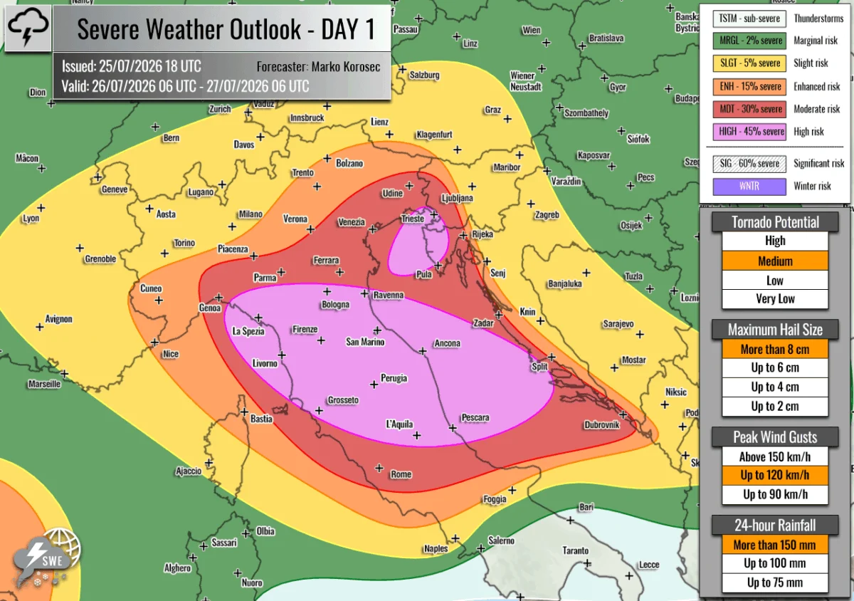
A volatile atmospheric setup is set to collide with the peak of the European summer tourist season, as forecasters have issued a significant severe weather warning for Sunday, July 26. A powerful, organized storm outbreak is expected to sweep across the north-central Mediterranean and the Adriatic Sea, bringing with it a cocktail of extreme hazards, including giant hail, destructive winds, intense tornadic activity, and catastrophic flash flooding.
Main Facts: A Complex Meteorological Collision
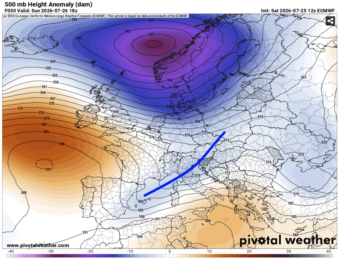
The synoptic situation for Sunday is characterized by a deep, stationary upper-level low positioned over Northern Europe, trapped between two formidable high-pressure ridges—one over the North Atlantic and the other over Russia. This "blocked" pattern has forced a secondary, highly active wave to traverse Central Europe, sliding into the Mediterranean basin.
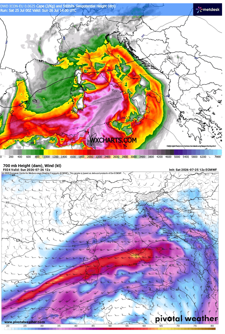
As this wave interacts with the extreme, residual heat stored within the Mediterranean waters, it creates a "pressure cooker" effect. The environment is primed with exceptional levels of instability; Meteorological models indicate Convective Available Potential Energy (CAPE) levels reaching 2,000 to 3,000+ J/kg across the Tyrrhenian and Adriatic regions. When combined with intense wind shear generated by a powerful mid-level jet stream, the stage is set for the explosive development of supercell thunderstorms.
Chronology of the Event
The progression of this weather event is expected to begin in the early morning hours of Sunday, July 26, and persist through Monday morning, July 27.
- Early Morning (Sunday): Initial convective development is expected in the Ligurian Bay. As these storms tap into the moisture-rich air flowing off the warm sea, they will rapidly organize into multicell clusters and intense supercells.
- Mid-Day (Sunday): The storm system will track eastward across the Apennine Mountains. This phase is critical as the complex terrain will likely exacerbate the moisture convergence, leading to high-intensity, "training" thunderstorms that stay over specific geographic locations for extended periods.
- Afternoon and Evening (Sunday): The focus shifts toward the Adriatic Sea. The North Adriatic, particularly the Istrian coast of Croatia and southwestern Slovenia, faces a high risk of stationary convective bands. Forecasters anticipate a 6-to-12-hour window where these storms could dump between 100 mm and 200 mm of rain, significantly increasing the risk of flash flooding.
- Overnight (Sunday to Monday): The system is expected to push into the Western Balkans, maintaining a high level of intensity, though the convective mode may transition as the primary forcing moves toward the east.
Supporting Data and Meteorological Analysis
The technical data provided by Severe Weather Europe paints a dire picture of the thermodynamic variables at play.
Instability and Moisture
The "High-PWAT" (Precipitable Water) environment, measured between 45–60 mm, indicates an atmosphere saturated with water vapor. This serves as the fuel for the intense rainfall rates expected across Northern Italy and the Adriatic coastline. Because the ground in many of these regions has been baked by recent heatwaves, the soil’s ability to absorb such high volumes of water in a short period is severely diminished, making the threat of runoff and flash flooding nearly certain in the target zones.
Wind Shear and Tornadic Potential
The presence of a mid-level jet stream provides the necessary "spin" in the atmosphere to support rotating storms. Forecasters are particularly concerned about the western portions of the High-Risk zone in Central Italy, where storm-relative helicity—a measure of the potential for rotating updrafts—is at its peak. This environment is highly conducive to the formation of tornadic supercells. Waterspouts are also a major concern for the Adriatic corridor, which could pose an immediate threat to maritime activities and coastal infrastructure.
Hazard Categorization
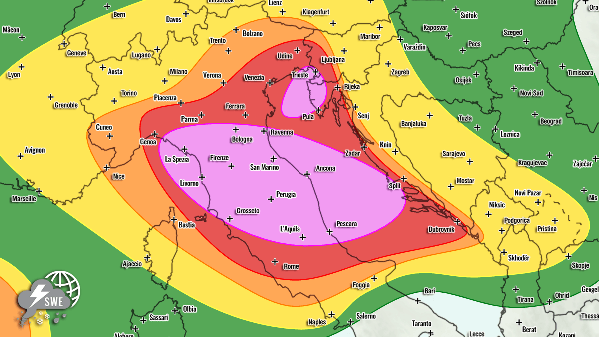
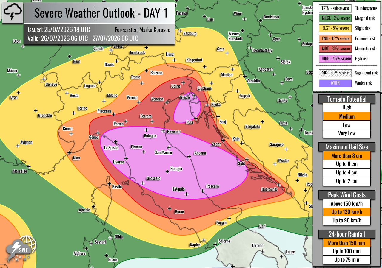
- HIGH Risk: Central and Northern Italy, Central Adriatic Sea, Northeast Adriatic (Istria, Croatia), and Southwestern Slovenia. These areas are expected to see the most robust storm development, including giant hail (10+ cm in diameter), hurricane-force wind gusts, and severe flooding.
- MDT/ENH/SLGT Risk: Southern/Western Croatia, Western/Central Slovenia, West-Central Austria, and Southern Switzerland. While storm coverage here may be more scattered than in the HIGH risk zones, individual cells remain capable of producing significant damage.
Wider Continental Implications
While the Mediterranean is the primary focus of this outbreak, the atmospheric instability is not confined to the south. An ENH risk area has been highlighted for the Western Mediterranean, specifically between Northeast Spain and the Balearic Islands, where isolated but intense storms may develop.
Further north, the tail end of the upper-level wave is expected to impact the Netherlands, Northern Germany, and Poland. While the intensity will not match that of the Italian outbreak, residents in these regions should remain vigilant for severe wind gusts and marginal hail.
Additionally, a large ENH/SLGT risk has been issued for Southwestern Russia. Here, a different set of dynamics—high instability meeting a strongly sheared environment—is expected to produce discrete, organized supercells. The combination of high low-level shear and enhanced helicity in this region increases the likelihood of tornadoes, a hazard that is often overlooked in continental-scale reporting.
Implications for Public Safety and Infrastructure
The timing of this outbreak coincides with the height of the European summer tourist season. Millions of travelers are currently occupying coastal regions in Italy, Slovenia, and Croatia—areas that are now under a HIGH-risk designation for severe weather.
Emergency Preparedness
- Coastal and Maritime Safety: Authorities in the Adriatic regions are urged to issue warnings for small craft and ensure that tourists in coastal areas are aware of the potential for sudden, violent weather. Waterspouts, which can move inland, present a specific danger to beachgoers.
- Flash Flood Mitigation: Given the extreme forecast for rainfall accumulations (100–200 mm in some locations), local municipalities should prepare for the inundation of low-lying urban areas and potential infrastructure failures.
- Agriculture and Aviation: The threat of giant hail poses a catastrophic risk to agricultural interests, particularly in the Po Valley and the inland regions of Italy. Furthermore, the combination of severe winds and supercell activity will likely lead to significant flight delays and potential ground-stop orders at major regional airports throughout the Sunday travel window.
Official Guidance
Residents and travelers in the affected zones are advised to monitor local meteorological services and adhere to all civil protection alerts. The speed at which these storms can develop and intensify means that reaction time will be limited. As the storm system evolves, the "training" effect of the thunderstorms will be the deciding factor in the severity of the flooding; individuals in high-risk zones should have a plan to move to higher ground if they observe rapid water level rises.
As the situation unfolds, the combination of high-resolution numerical weather prediction models and real-time radar tracking will be essential for issuing precise warnings. This event serves as a stark reminder of the volatility of the Mediterranean climate when deep-seated heat energy meets a significant, cold-core upper-level disturbance.