As September draws to a close, a meteorological phenomenon of significant intensity is defying the seasonal transition across the European continent. A massive Heat Dome has established itself, ushering in an unseasonably warm spell that is expected to persist well into the opening days of October. Driven by a powerful upper-level ridge surging northward from the Mediterranean and North Africa, this thermal anomaly is setting the stage for what meteorologists describe as an exceptional late-season weather event.
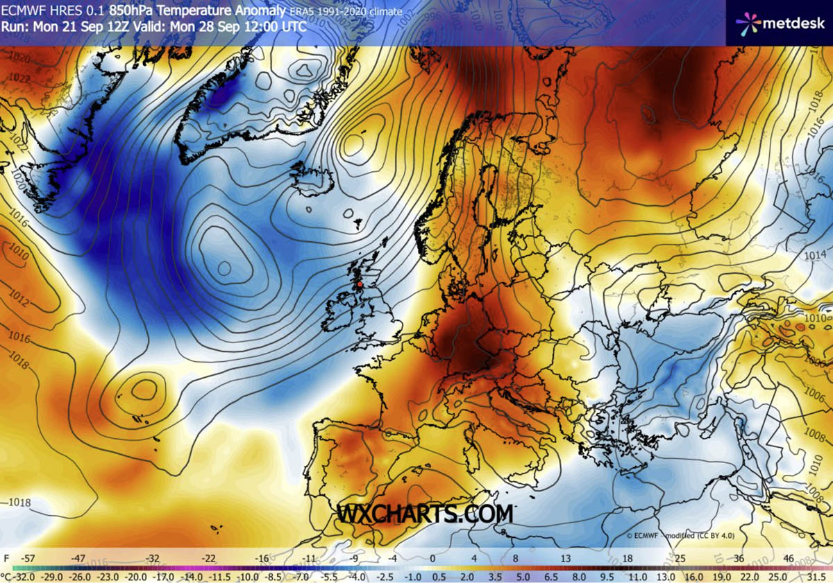
With temperature anomalies at the 850 hPa level—the altitude where atmospheric temperatures are measured without surface interference—climbing 8 to 12°C above long-term averages, vast portions of Western, Central, and Northern Europe are bracing for record-breaking heat.
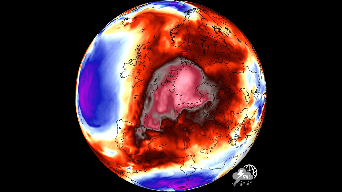
The Synoptic Mechanism: An Atmospheric Dipole
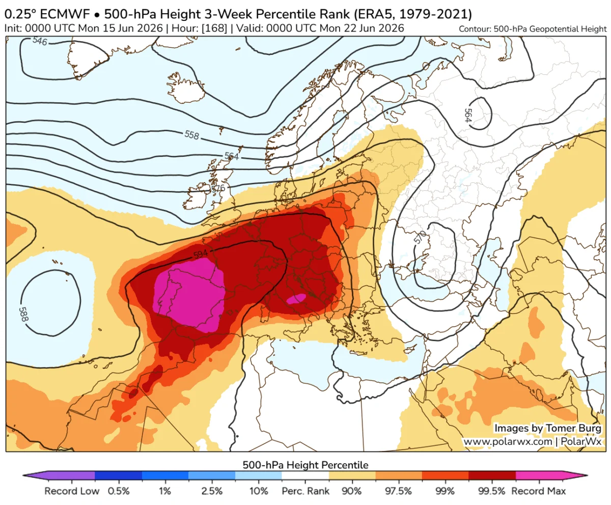
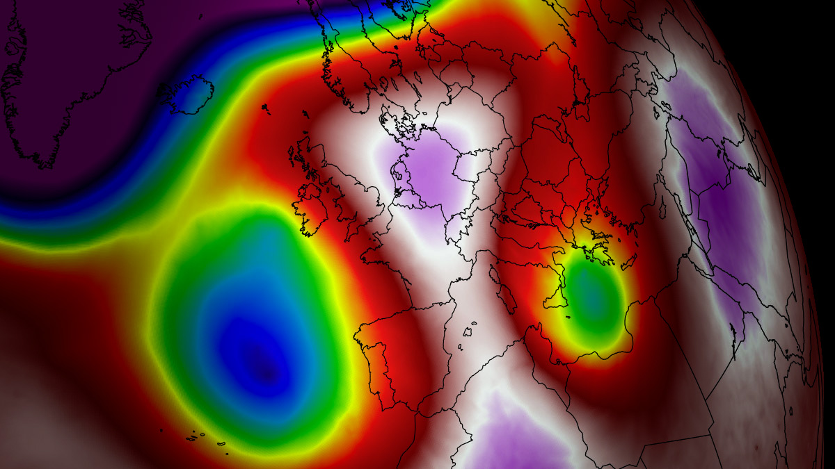
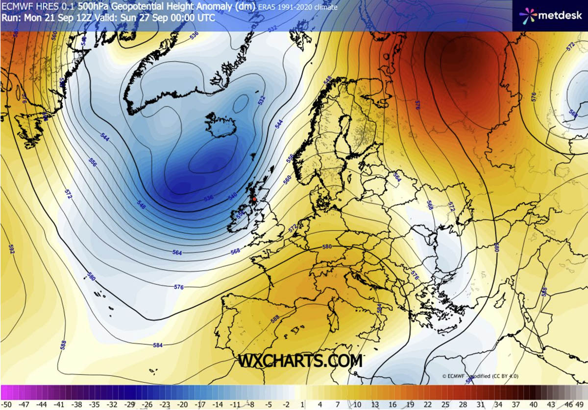
The primary engine behind this late-autumn thermal surge is a classic atmospheric dipole pattern. A deep, high-amplitude upper-level trough has established itself over the North Atlantic, acting as a catalyst that forces an intense southerly jet stream to pull warm, tropical air from the Sahara and the Mediterranean deep into the heart of the continent.
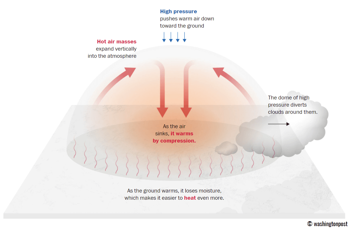
Beneath the core of this expansive blocking ridge, the atmosphere is undergoing intense subsidence. This process compresses and warms the lower layers of the air mass, effectively acting as a "lid" on a pot. By suppressing cloud cover and encouraging clear, sunny skies, the system is driving afternoon surface temperatures well into the high 20s, with peaks expected in the low 30s in many regions—a stark contrast to the crisp, cooling weather typically associated with late September.
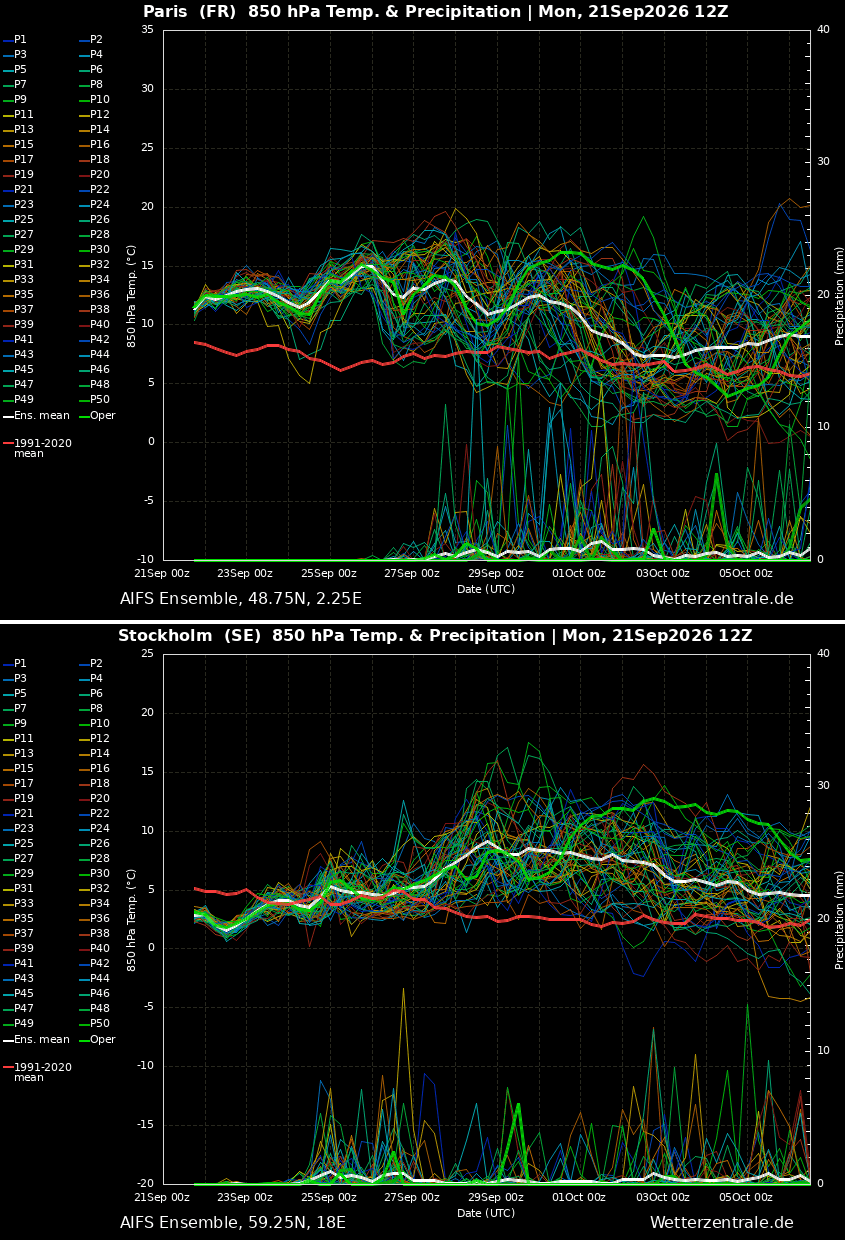
Chronology: From Iberian Scorcher to Nordic Warmth
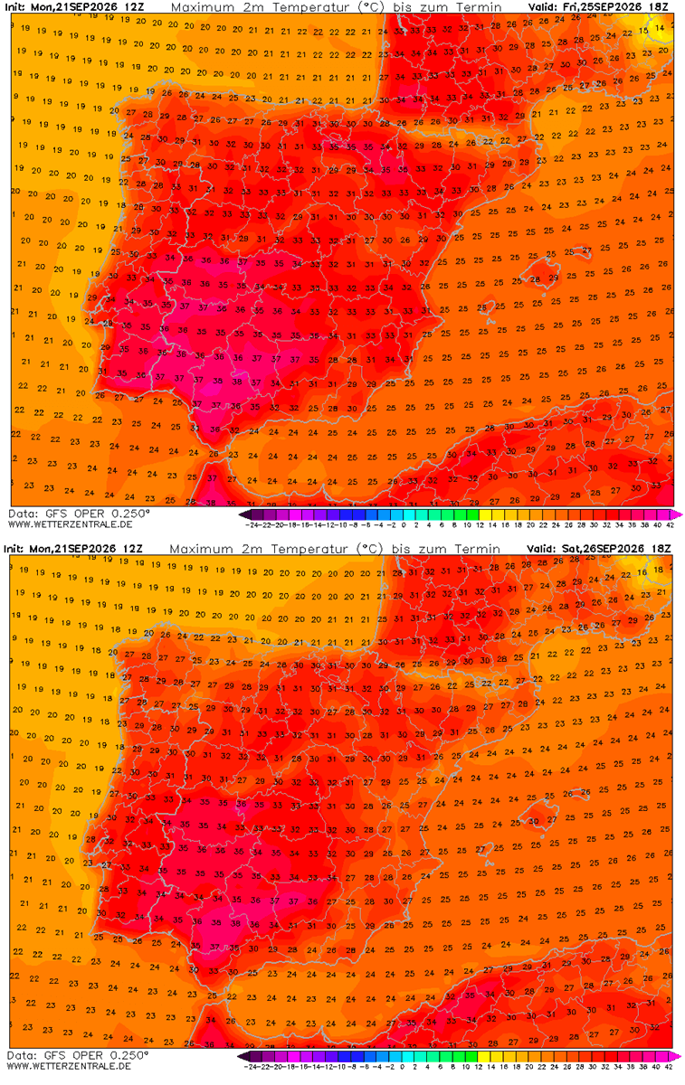
The progression of this heatwave is methodical. Through the remainder of this week, the core of the heat will be anchored over the Iberian Peninsula, where temperatures are forecast to push toward 40°C in parts of Spain and Portugal.
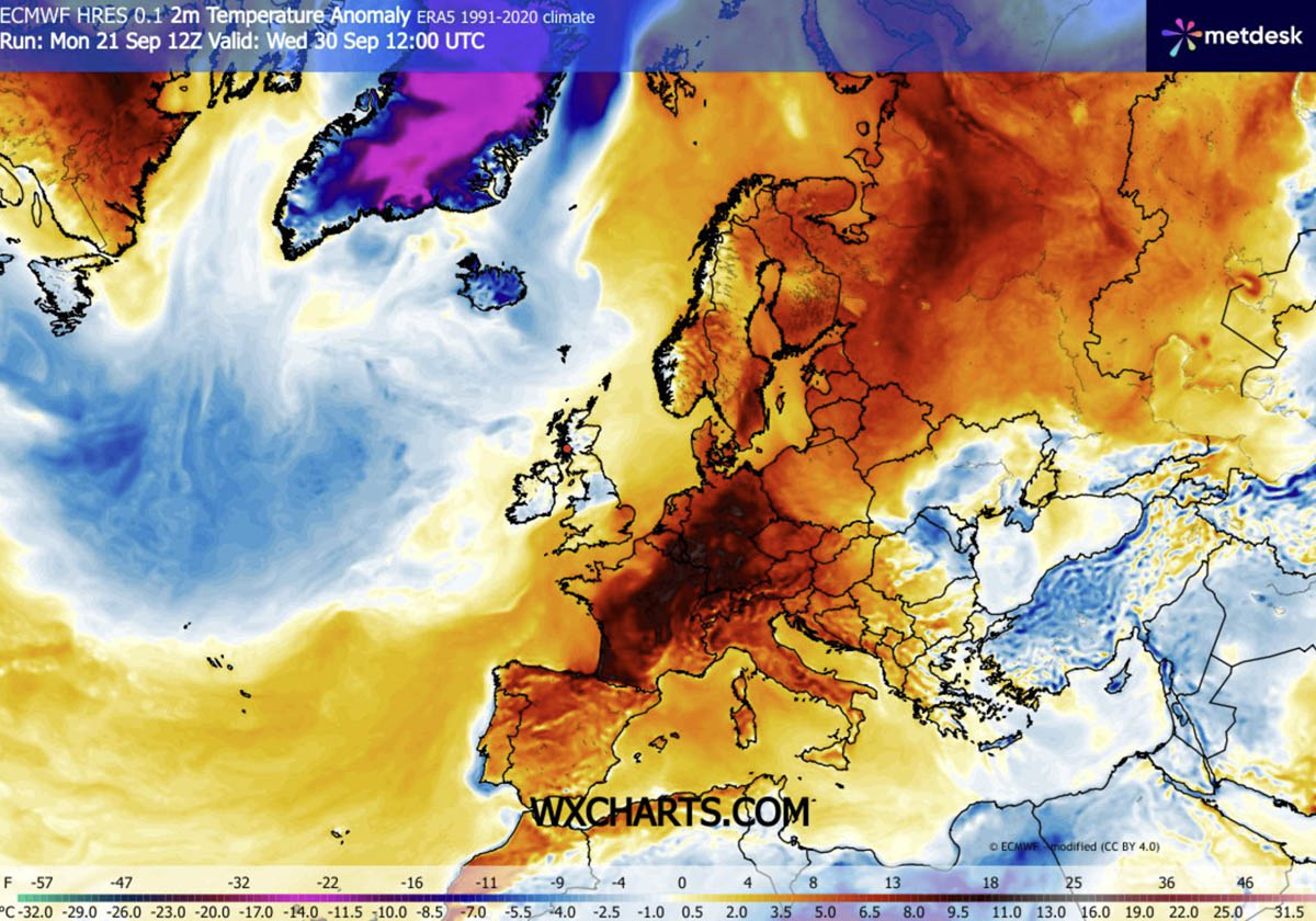
As the calendar turns toward October, the high-pressure block will shift, restricting Atlantic weather systems to the far western fringes of the continent. By the weekend, the heat will migrate northward and eastward, engulfing France, the Benelux region, and Germany.
Looking toward early October, the ridge is projected to extend its influence into Scandinavia. Forecast models from the GFS and ECMWF indicate that Sweden and Finland will experience significant thermal anomalies, with temperatures soaring well above their historical averages for the first week of October. This creates a sharp, dangerous boundary between the arid, sweltering heat of Central Europe and the wet, stormy conditions forced into the Atlantic by the blocking ridge.
Regional Breakdown: Where the Heat Hits Hardest
Southwestern Europe: The Epicenter
Spain and Portugal are currently bearing the brunt of the atmospheric compression. Until the weekend, inhabitants can expect daytime highs ranging between 34°C and 38°C. This extreme, dry heat poses a significant risk to agricultural output and fire safety, as the region remains locked under the influence of the Saharan plume.
Western Europe: France and the Benelux
In France, the intensity of the heat will peak in the southern and central departments. Mid-30s temperatures are anticipated, while northern France and the Benelux countries will see mercury readings comfortably in the low 30s by the weekend. For these regions, this represents a significant departure from the expected autumnal decline in temperatures.
The United Kingdom: A Brief Taste of Summer
While the UK will avoid the most extreme temperatures seen on the continent, the country is not immune. Southern and central England will see a period of mid-to-upper 20s through Sunday. While pleasant for many, it serves as a reminder of the sheer reach of this atmospheric ridge. Conversely, western Ireland and Scotland will experience the other side of this weather pattern: high-moisture inflow from the Atlantic, leading to significant orographic rainfall that could reach accumulations of 150mm in some localized areas.
Central and Northern Europe: A New Frontier
As the heat dome shifts east, Germany, Poland, and the Baltic states will experience a late-season surge. Temperatures approaching 30°C are possible in Germany, while the most anomalous heat relative to local norms will likely be recorded in Scandinavia.
The Science of the "Heat Dome"
To understand the gravity of this event, it is vital to define the "Heat Dome" phenomenon. It is essentially a persistent, stagnant area of high pressure that traps warm air in the lower atmosphere. Because the air is constantly being pushed downward by the high-pressure system, it becomes compressed and heats up further—a process known as adiabatic heating.
This "lid" also prevents cooler air from entering the region and blocks rain-bearing clouds. In the current European context, the system is remarkably stable, suggesting that the "early autumn cooling" usually expected by October will be delayed by at least a week to ten days.
Health and Infrastructure Implications
The persistence of this weather pattern brings with it serious health risks. Medical professionals and government health agencies have issued warnings regarding "tropical nights"—periods where the ambient temperature does not drop below 24°C.
The human body relies on the nighttime hours to dissipate heat accumulated during the day. When temperatures remain high at night, the body is denied this vital cooling window, leading to increased rates of heat exhaustion, dehydration, and strain on those with pre-existing cardiovascular or respiratory conditions.
The Heat Index Factor
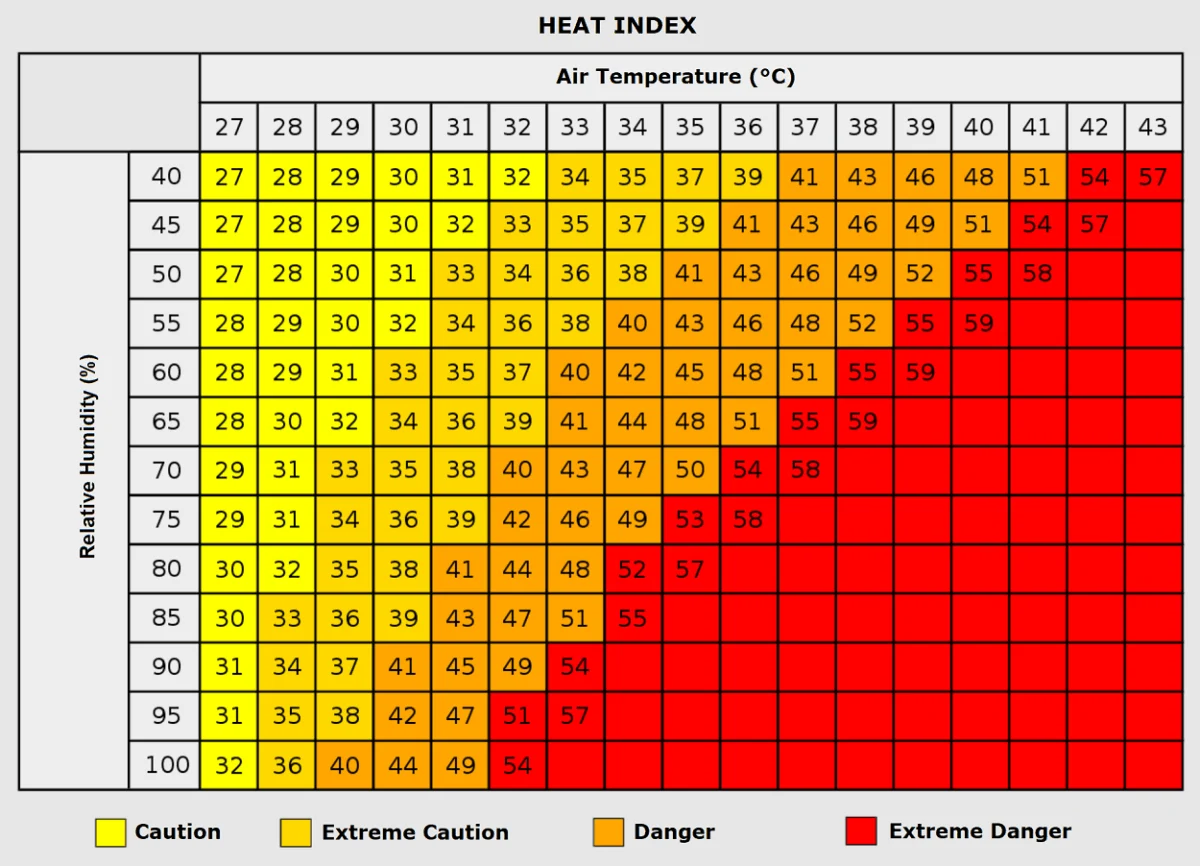
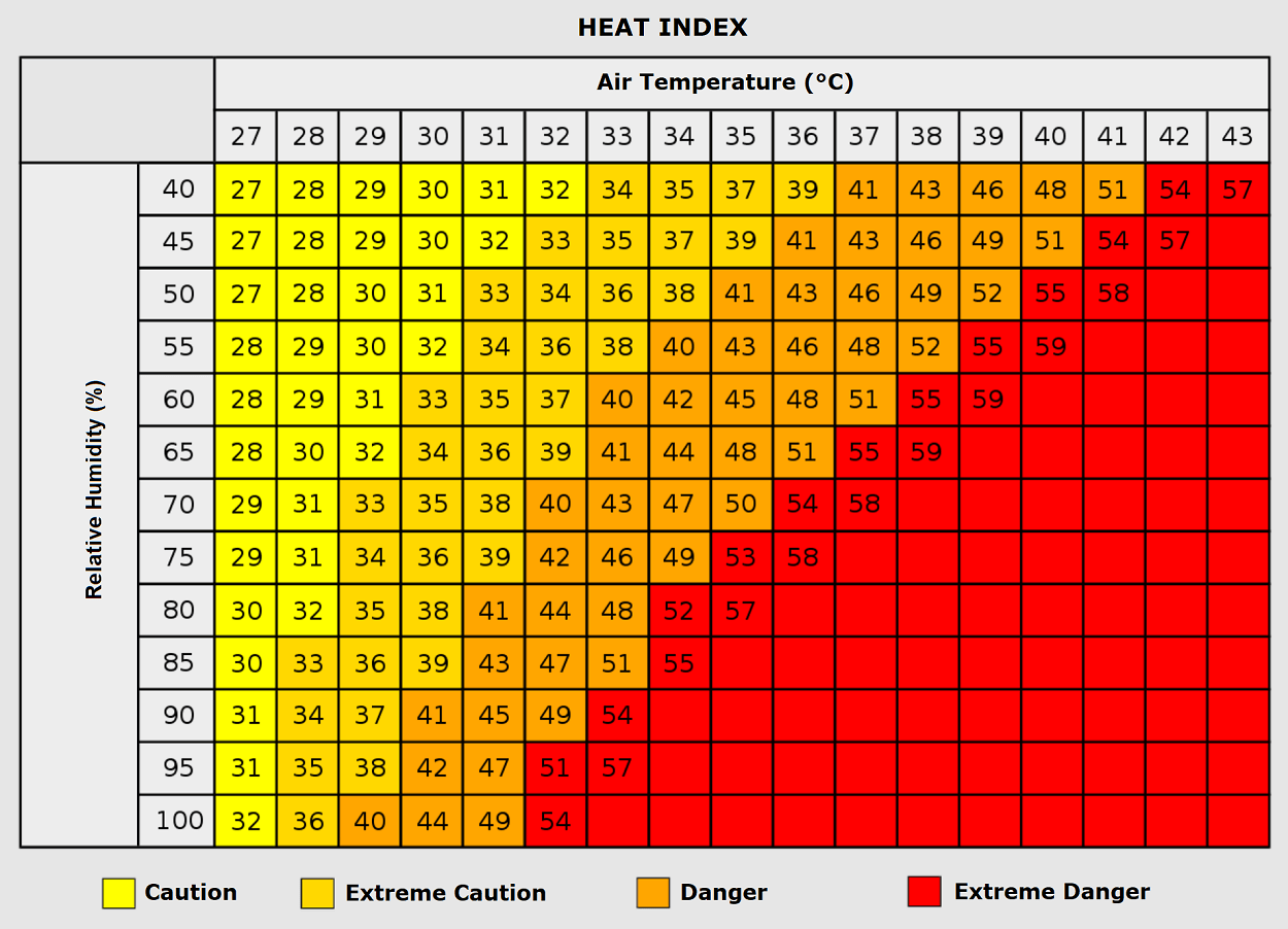
Humidity plays a critical role in how the human body experiences these temperatures. While the air may be dry in parts of Spain, other regions under the influence of the moisture-laden Atlantic jet stream may experience a higher "Heat Index." A temperature of 35°C combined with high humidity can feel like 50°C to the human body, drastically increasing the risk of heat stroke.
Grid and Economic Impact
Beyond public health, the prolonged heatwave places significant strain on energy grids. While cooling demand in September is usually lower than in mid-summer, the lack of seasonal cooling means that homes and businesses are maintaining air conditioning use for longer periods than is typical for the season. Additionally, agriculture faces a "double whammy": extreme heat in the south and potential flood risks from heavy rainfall in the west, disrupting harvest cycles and logistical supply chains.
Official Responses and Meteorological Outlook
While this specific event is currently being managed by regional authorities through public health advisories, the broader trend of late-season heatwaves has become a point of concern for climatologists.
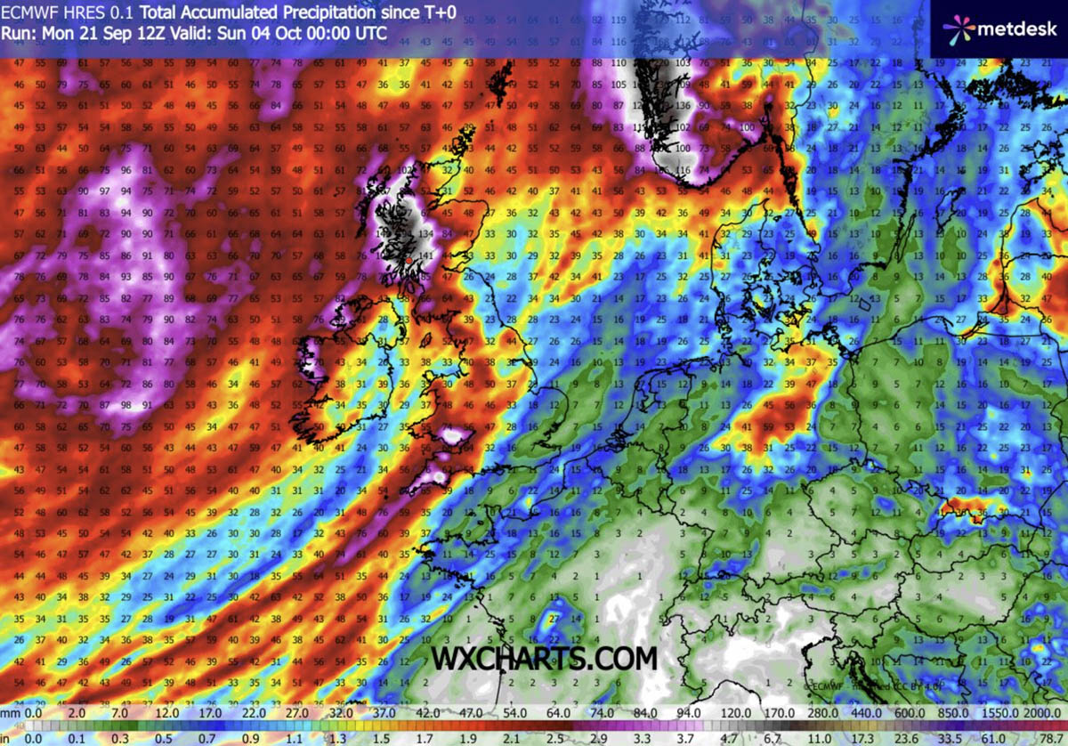
Meteorological agencies, including those monitoring the GFS and ECMWF models, are tracking the potential for this ridge to become "locked" in place. While long-range trends suggest a more dynamic, cooler pattern may return later in October, the current data confirms that the first week of the new month will be dominated by this anomalous warmth.
The atmospheric boundary between the cold, wet North Atlantic and the hot, dry continental Europe is the defining feature of this crisis. As the ridge expands, it creates a "temperature gap" that is rarely seen at this time of year. Residents are advised to stay informed through local meteorological services, maintain hydration, and take necessary precautions against heat stress, particularly during the peak afternoon hours.
As the continent prepares to transition into the final quarter of 2026, the current weather pattern serves as a potent reminder of the volatility of our atmospheric systems. Whether this heat dome will yield to the natural progression of autumn or continue to rewrite the climate records for the coming month remains a subject of intense focus for the global scientific community. For now, the message is clear: the summer heat has not yet retreated, and the season of autumn will be forced to wait.