After an exhausting and historic stretch of relentless, blistering heat that gripped the European continent for weeks, a significant atmospheric transformation is underway. A massive, high-amplitude weather shift is finally delivering a much-needed, deep cold refreshment to the eastern half of Europe. For millions of residents in Central Europe and the Balkan Peninsula—who have been battling stifling urban heat islands, compromised air quality, and consecutive “tropical nights”—this week marks a dramatic and welcome departure from the sweltering conditions of July 2026.
The Meteorological Engine: How the Pattern Flipped
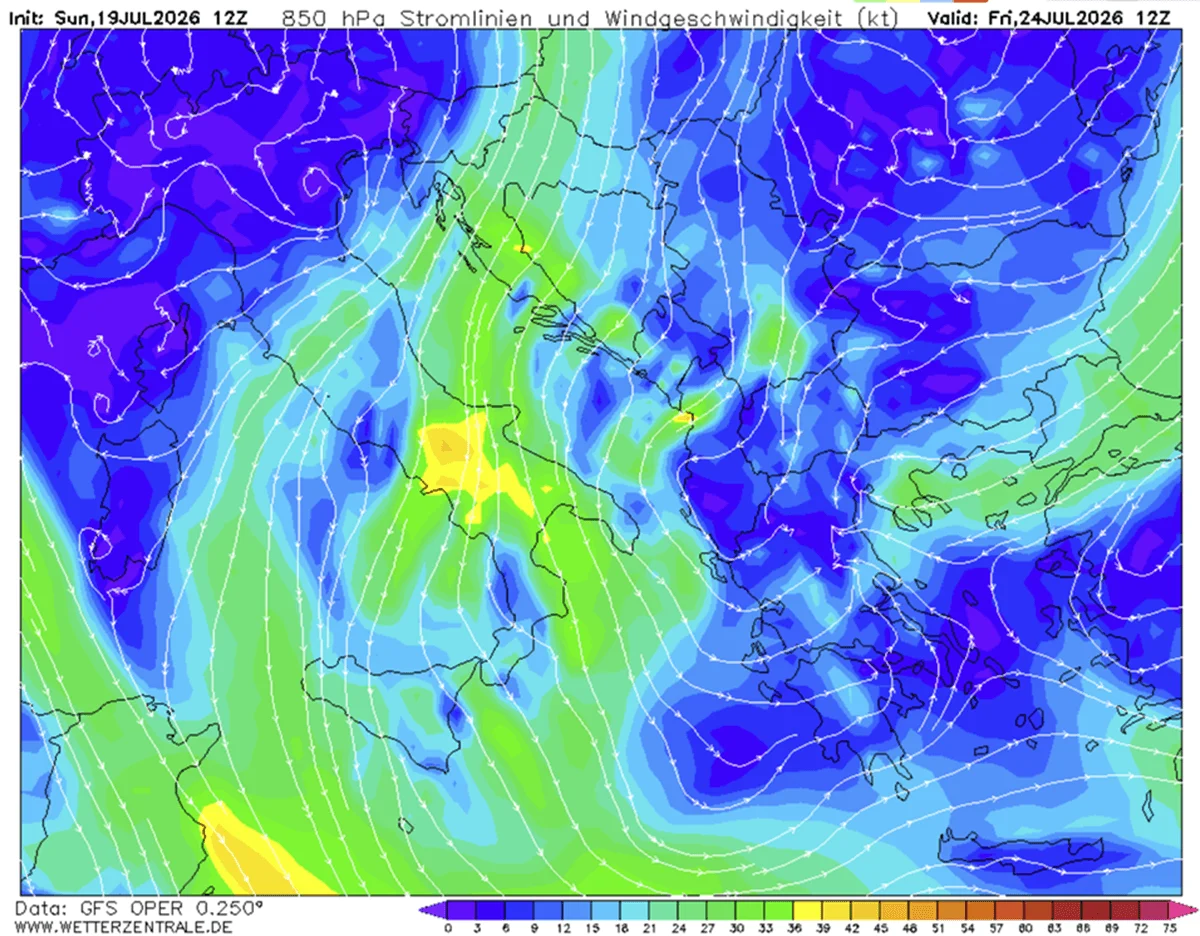
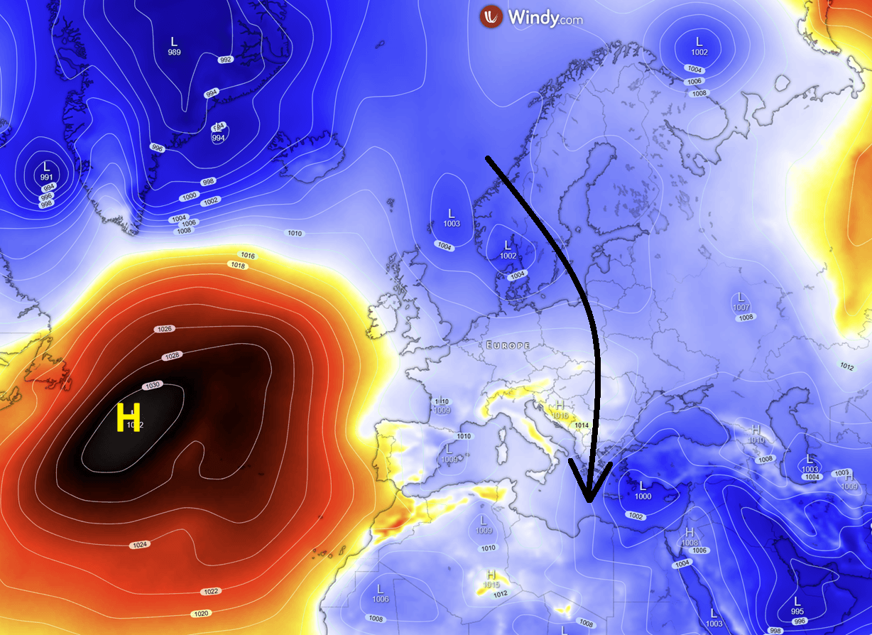
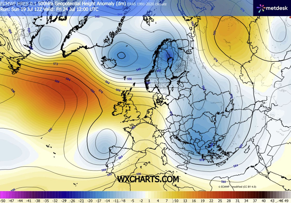
The driving mechanism behind this abrupt climate pivot is a sophisticated reconfiguration of the upper-level flow. A robust high-pressure ridge has strengthened over the North Atlantic, acting as an atmospheric barrier that has forced a deep, meridional flow. This structural shift allows a massive, unstable cold air mass originating from the high latitudes to push southward, sweeping across the continent with remarkable efficiency.
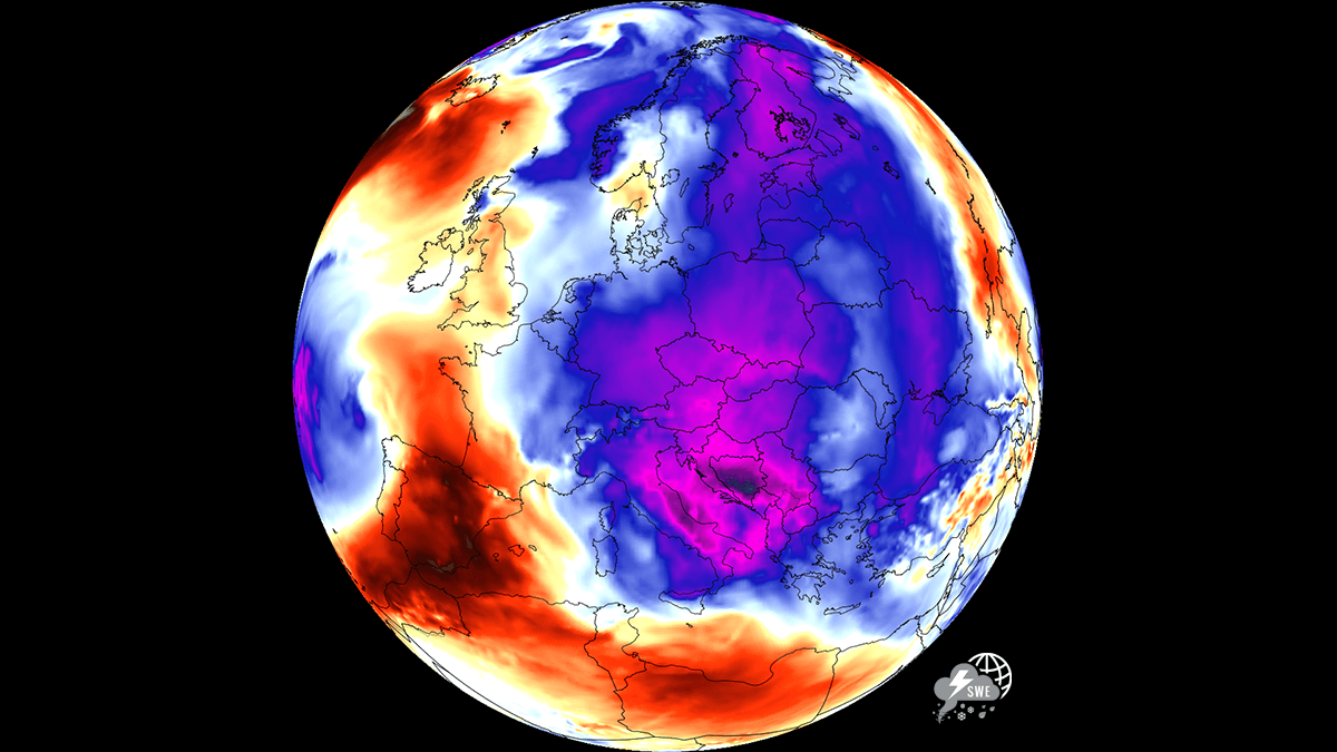
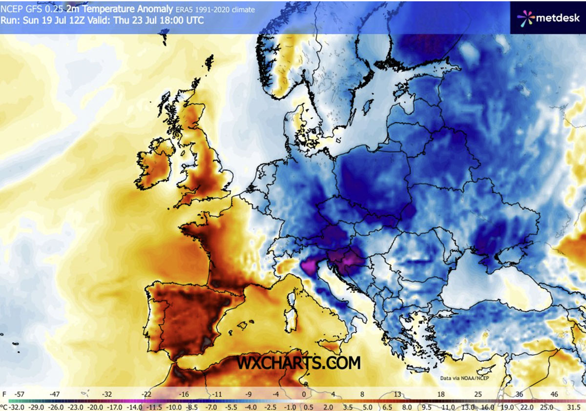
As this deep low-pressure system settles, it is effectively dismantling the heat domes that previously dominated the region. By mid-week, daytime highs are projected to plummet to comfortable, seasonable averages—consistently staying below the 30°C threshold. For cities in Hungary, Poland, Romania, and across the Balkans, this is not merely a dip in mercury; it is a vital reprieve, allowing buildings and urban infrastructure to finally shed the thermal load accumulated over the past month.
Chronology of the Cold Wave
The transition began in earnest early this week as the leading cold front advanced from Northern Europe.
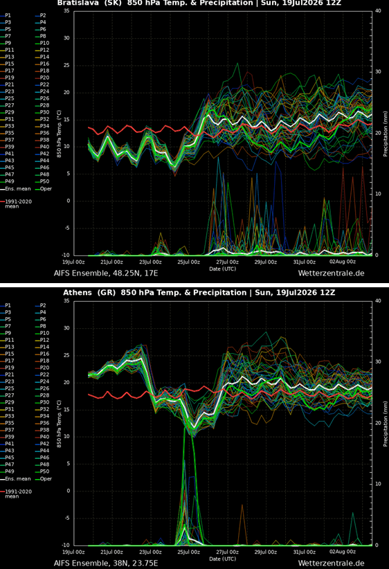
- Mid-Week (Tuesday/Wednesday): The cooling trend initiated across Central Europe. The influx of northerly air began to displace the stagnant heat, dropping temperatures by 4–8°C below seasonal norms. Breezy conditions accompanied the front, further exacerbating the feeling of coolness.
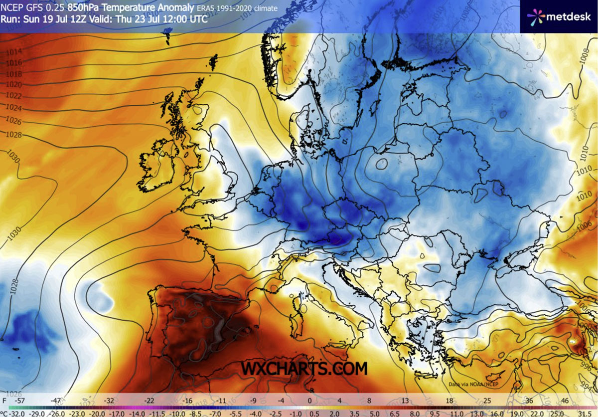
- Thursday: The core of the cold air mass pushed deeper into the heart of the continent. Countries including Austria, Czechia, Slovakia, and Poland experienced significant temperature anomalies, with morning lows dipping into the low-to-mid 10s.
- Friday and Saturday: The most intense phase of the cold wave is expected to reach the southern Balkans, including Greece and parts of Italy. Atmospheric models indicate a 10–12°C drop below the long-term July average in these regions.
- The Weekend: Due to persistent upper-level blocking over the Atlantic, the cool-down is expected to hold firm through the weekend, providing an extended period of relief during the peak of the European tourist season.
Supporting Data: Anomaly and Intensity
Meteorological data from July 2026 confirms the severity of this shift. While the northern and central regions are seeing temperatures return to historical averages, the southern Balkans and the Eastern Mediterranean are witnessing one of the most impressive downward anomalies of the summer.
The 850mbar temperature anomalies—a key metric for meteorologists to track the intensity of air masses—show a deep blue swath of air moving from the Arctic and Northern Europe directly into the Mediterranean basin. By Friday, the lowest layers of the atmosphere in these regions will be significantly colder than anything seen since the start of the heatwave.
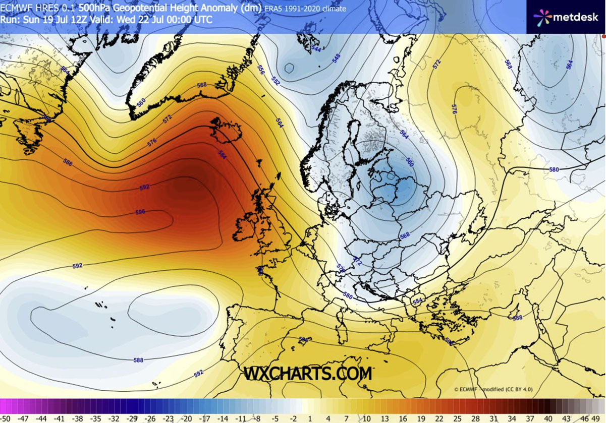
Furthermore, the pressure gradient between the high-pressure ridge in the west and the developing low-pressure trough in the east will generate persistent, gusty winds. While these winds are integral to the cooling effect, they present a double-edged sword. The lack of significant rainfall in some areas, combined with the drying effect of these winds, means that despite the drop in temperature, the wildfire risk remains critically elevated across the Balkans and parts of Central Europe.
Implications for Public Safety and Infrastructure
The human impact of this shift is profound. During the preceding weeks, “tropical nights”—where temperatures fail to drop below 20°C—put an immense strain on public health, particularly for the elderly and those in high-density urban environments.
Urban Resilience
Urban planners note that the current cooling phase allows for “thermal recovery.” Concrete and asphalt in major cities have been holding heat for weeks, creating a cycle where even nighttime provides little comfort. The current drop in nighttime temperatures to the low-to-mid 10s will allow residential buildings to ventilate, significantly reducing the energy demand for air conditioning and providing much-needed rest for the population.
The Conflict of Air Masses
The collision between the invading cold, dry air and the lingering, moisture-rich heat of the Mediterranean is a volatile meteorological event. This clash is fueling significant atmospheric instability. From Italy through the southern Balkans and toward the Black Sea, the stage is set for intense, scattered thunderstorms.
While these downpours are expected to provide localized drought relief and assist in cooling the parched landscape, meteorologists warn that they are likely insufficient to fully negate the extreme wildfire risk. The landscape remains tinder-dry, and sudden lightning strikes associated with these storms could ignite new fire fronts in the Southern Balkans and Greece.
Regional Disparities
It is important to note that this is not a pan-continental cooling event. While Eastern and Central Europe enjoy the crisp, refreshing air, the Iberian Peninsula is currently moving in the opposite direction. Spain and Portugal continue to face extreme, record-breaking heat, with temperatures hovering in the 40s. The atmospheric "blocking" pattern currently over the Atlantic serves as a wall, shielding the west from the refreshing northerly air while simultaneously trapping the heat over the southwest.
Looking Ahead: A Brief Pause
For millions across Eastern and Central Europe, this week offers a vital, if temporary, pause. The return to the low-to-mid 20s for daytime highs provides a window of normalcy before summer weather patterns evolve further.
However, experts advise that the volatility of the 2026 season should not be ignored. As the current trough shifts, the region will need to remain vigilant. The combination of high instability, potential for severe convective storms, and the lingering threat of wildfires means that emergency management services across the Balkans and Greece remain on high alert despite the lower temperatures.
As we move toward the next phase of the summer, the climate community will be watching closely to see if the current "Atlantic-Niña" influence—which has been identified as a factor in shaping this year’s unusual atmospheric behavior—will continue to dictate the pattern or if a new, more stable regime will emerge. For now, the residents of Eastern Europe can finally close their windows to the heat and embrace the cool, refreshing air of an unseasonably crisp July.
For ongoing updates regarding the developing heatwave in the Iberian Peninsula and the evolving, high-instability patterns in the Mediterranean, continue to follow our detailed meteorological reports.