August 6, 2026 – As we look toward the upcoming winter season, atmospheric scientists are closely monitoring a convergence of rare, high-impact climate signals. Early diagnostic data for the 2026/2027 winter season indicates a significant potential for a disrupted Polar Vortex—a development that could fundamentally reshape weather patterns across the United States, Canada, and Europe.
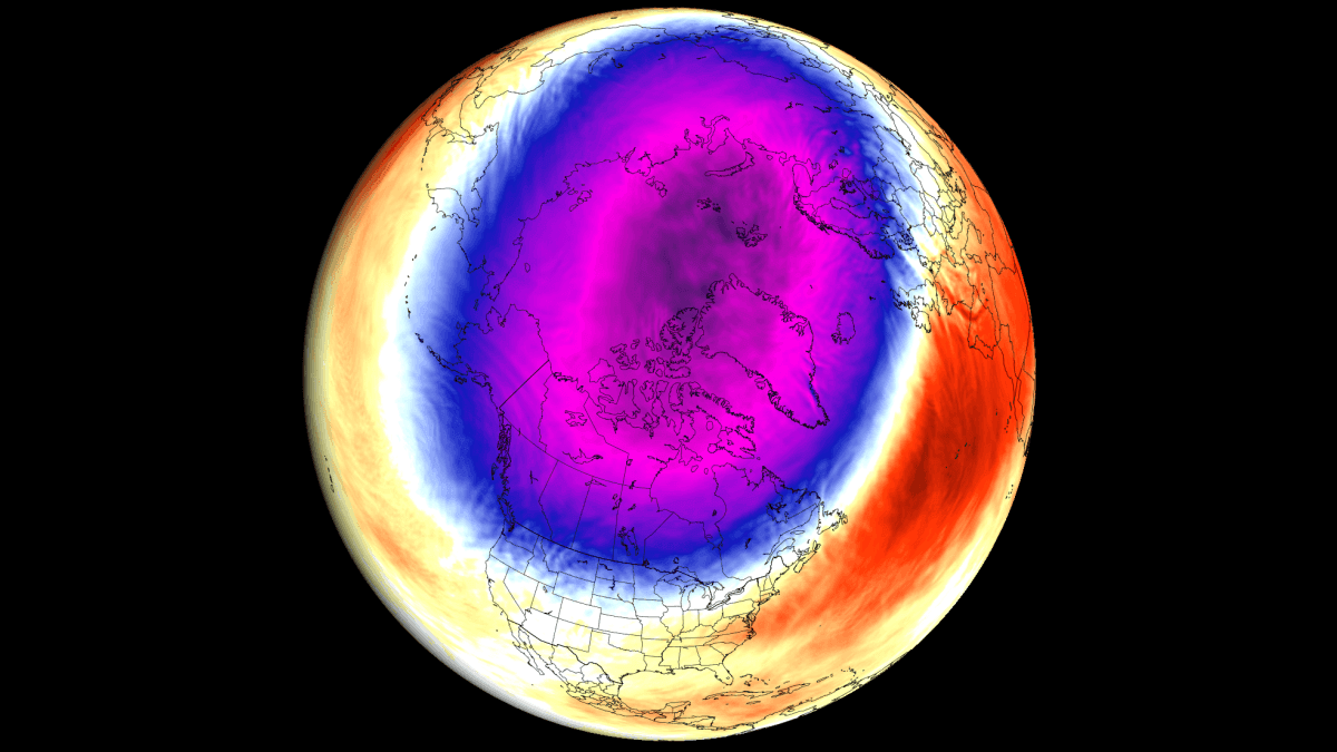
While the Polar Vortex is a natural, annual feature of our winter circulation, current models suggest that a "trinity" of global climate drivers—a developing Super El Niño, specific stratospheric wind anomalies, and record-low Arctic sea ice—are aligning to create a volatile environment for the Northern Hemisphere.
Main Facts: The Anatomy of a Disrupted Vortex
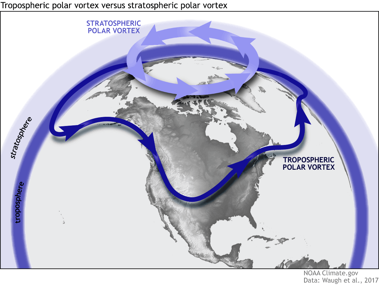
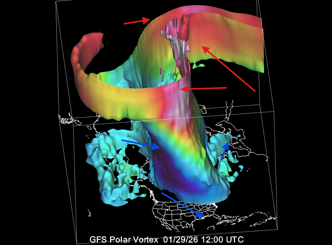
At its core, the Polar Vortex is a massive, spinning reservoir of cold air located in the stratosphere, approximately 30 miles above the North Pole. During a stable winter, it acts as a containment vessel, locking frigid Arctic air within the polar circle.
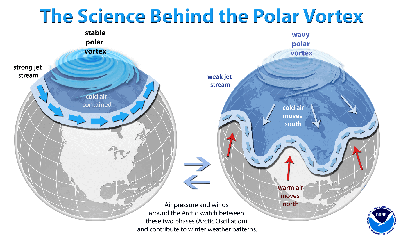
However, when this "spinning wall" is compromised, the results are immediate and often severe. A disruption or collapse of the vortex allows that trapped Arctic air to spill southward into the mid-latitudes, often leading to prolonged, extreme cold snaps and heavy snowfall in regions that might otherwise have experienced a milder season. For Winter 2026/2027, the primary concern is the emergence of a "weakening signal" in the stratosphere, detectable in long-range data for January 2027.
Chronology of Climate Drivers
The current forecast is not based on speculation but on a historical and observational timeline of three distinct, yet interacting, phenomena.
1. The Super El Niño Influence
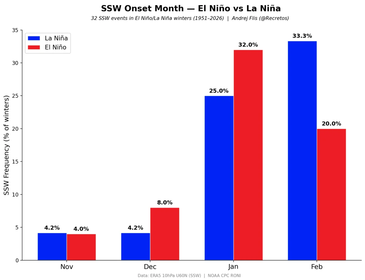
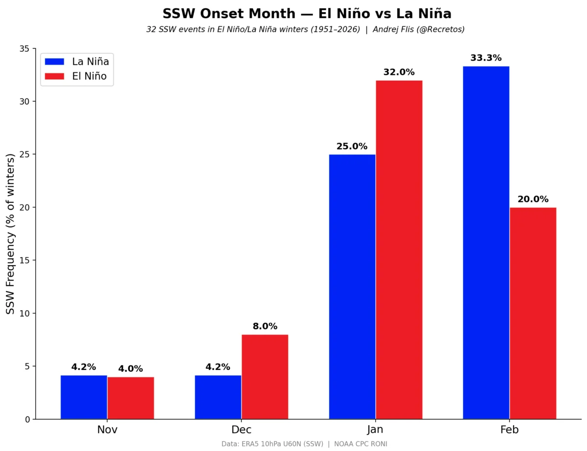
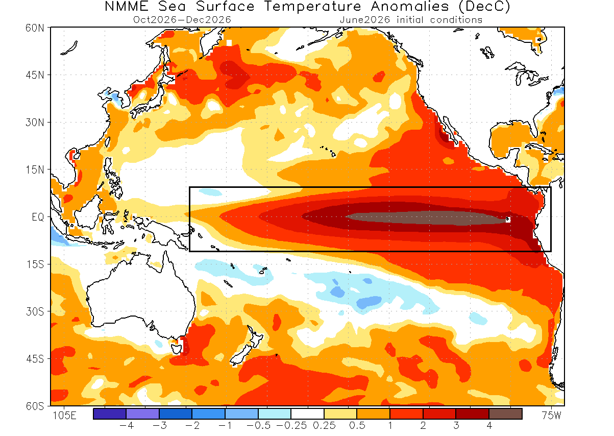
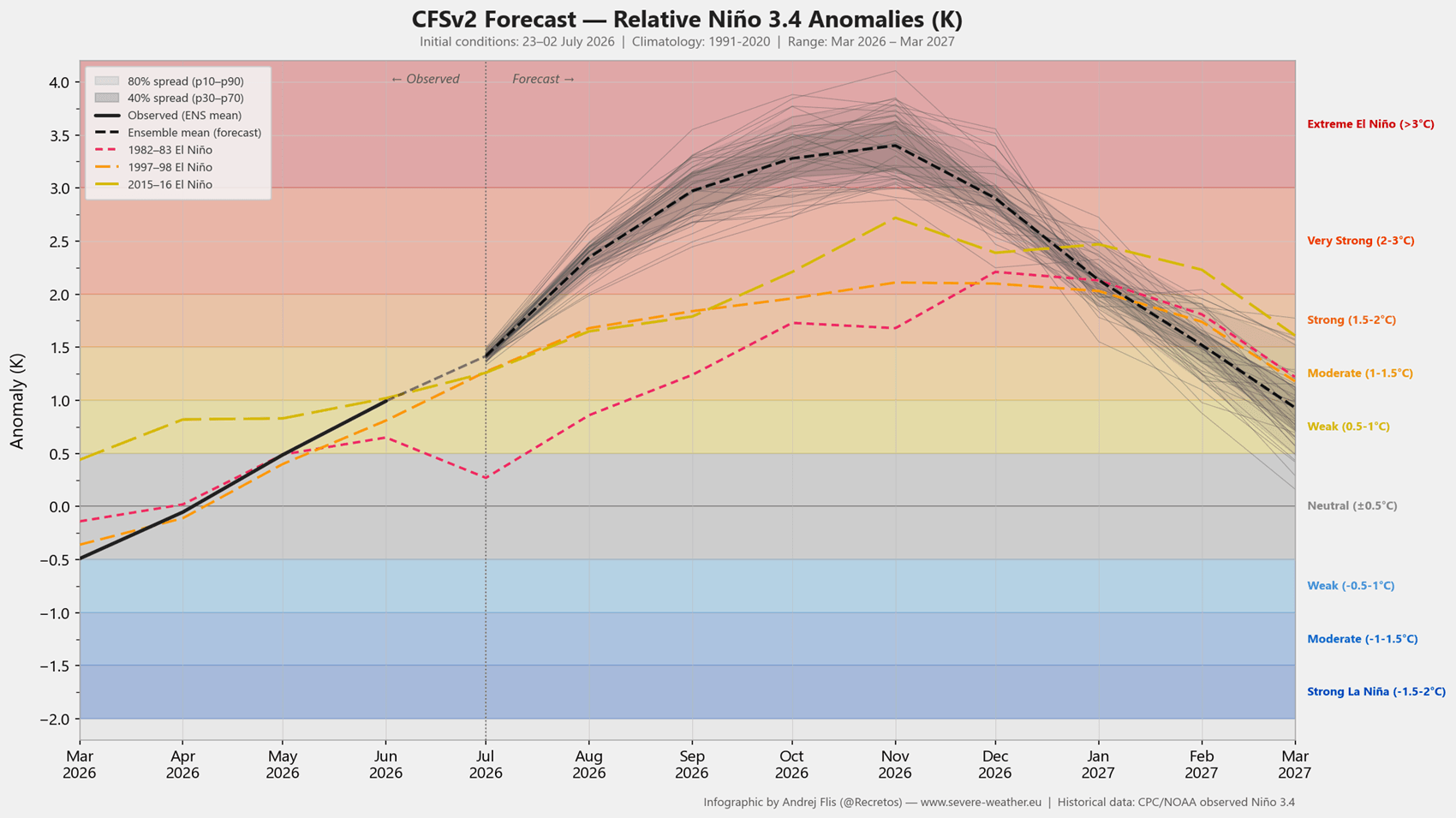
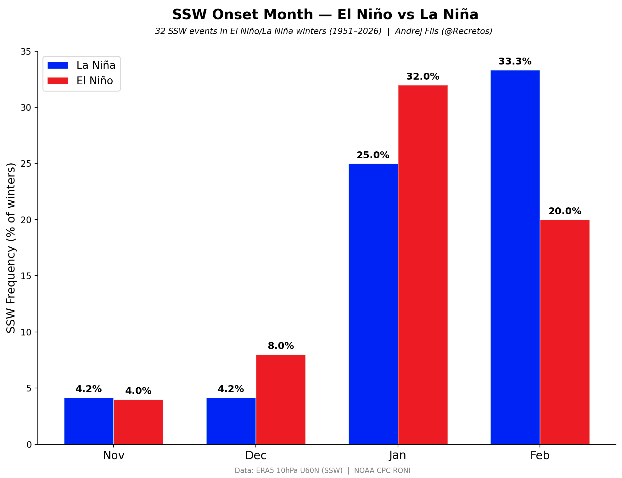
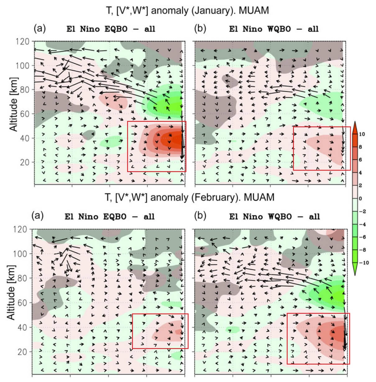
The equatorial Pacific is currently transitioning into one of the strongest El Niño events in decades. By late autumn, sea surface temperature anomalies are projected to exceed 4°C above the long-term average, crossing the threshold into "Super El Niño" status. Historically, Super El Niño events act as a catalyst for atmospheric waves. These waves travel vertically from the Pacific into the stratosphere, providing the necessary "energy push" to destabilize the Polar Vortex. Data from the NCEP CFSv2 model confirms this trend, showing a high probability of major vortex disruption specifically during the mid-winter months.
2. The Quasi-Biennial Oscillation (QBO)
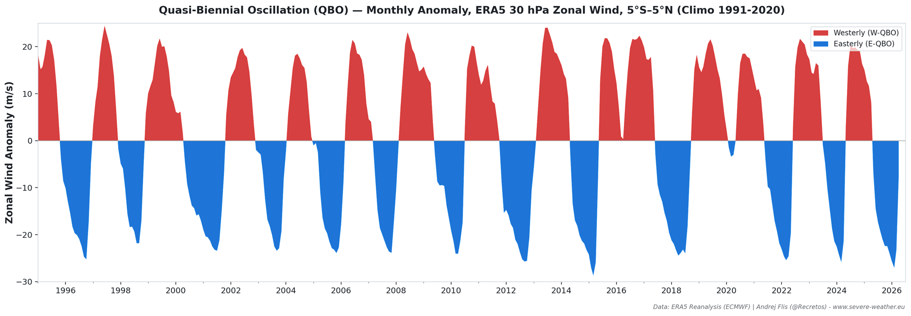
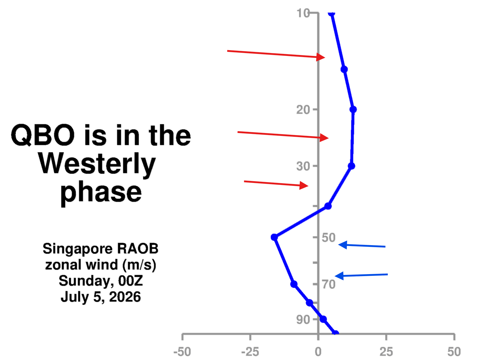
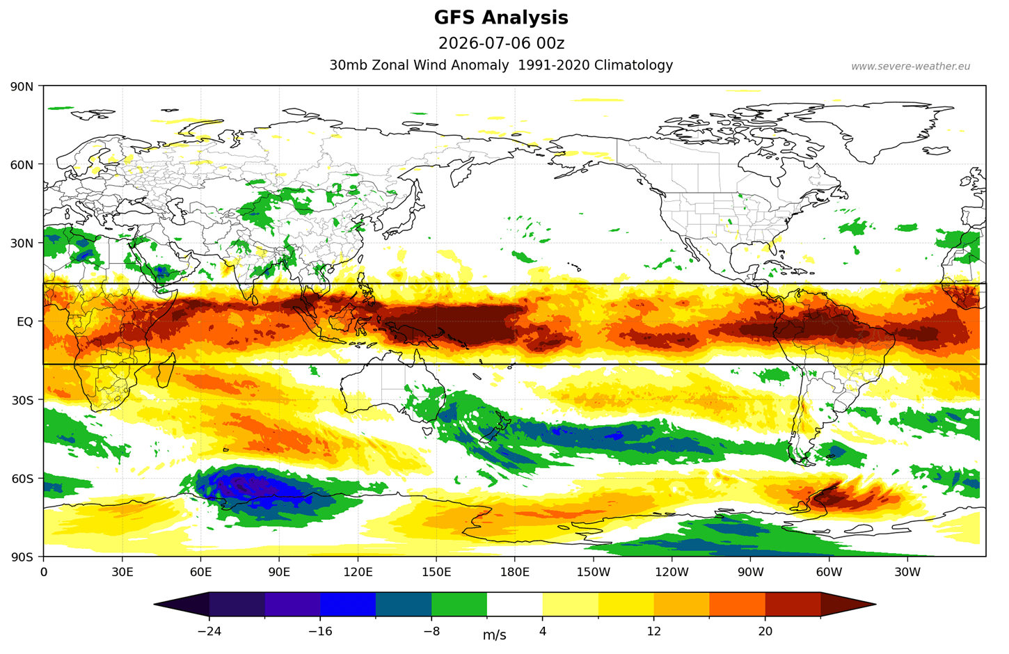
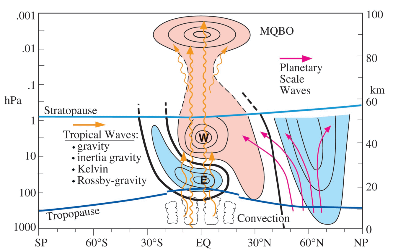
Often described as the "heartbeat of the atmosphere," the QBO is a periodic shift in wind direction high above the tropics. We are currently observing a transition into a westerly QBO phase. While a west-phase QBO typically promotes stability, the presence of a Super El Niño complicates this dynamic. The interaction between these two forces can "prime" the stratosphere for a collapse, particularly as the season transitions from December into January.
3. The Arctic Sea Ice Deficit
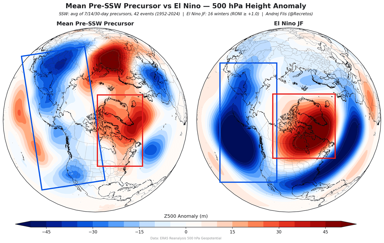
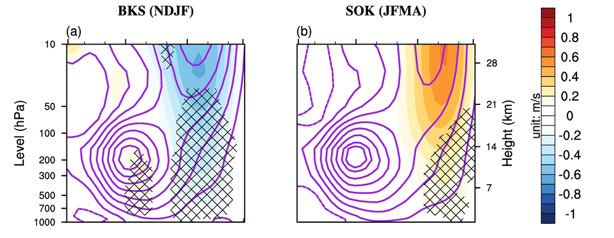
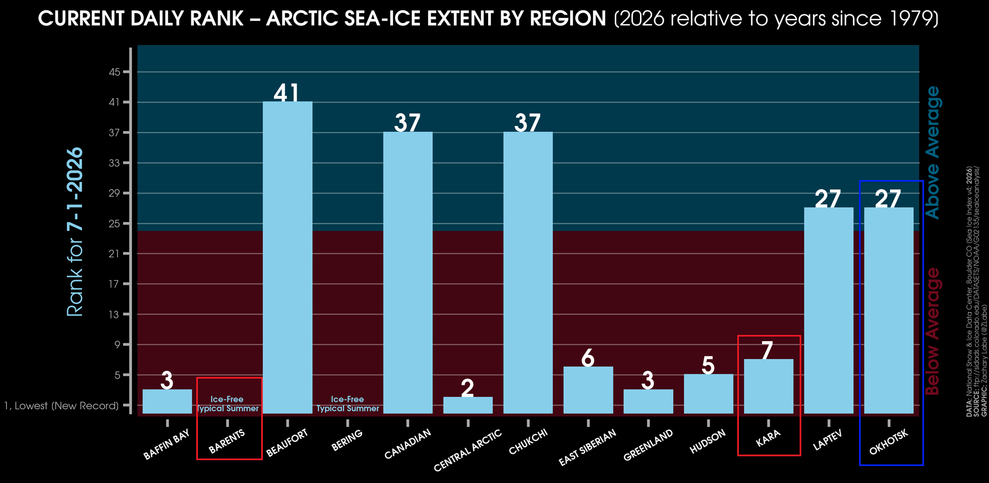
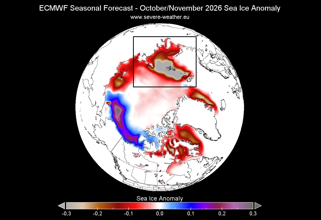
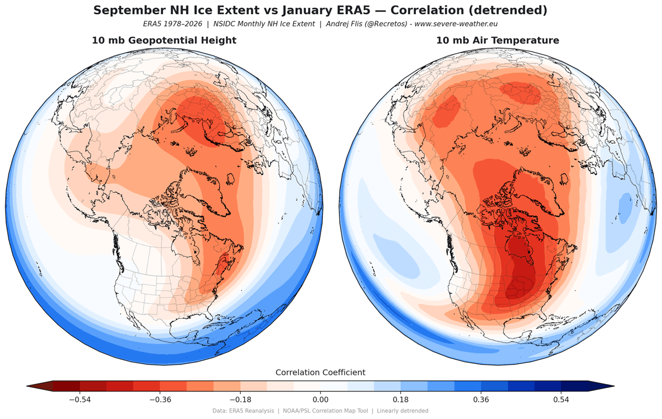
The state of the Arctic ice cap serves as a final, critical indicator. Current satellite observations show significant ice-free conditions in the Barents and Kara Seas. Research has established a direct correlation: low sea ice in these specific sectors reduces the strength of the Polar Vortex. By contrast, current ice levels in the Sea of Okhotsk are slightly above normal, creating a pressure imbalance that further encourages the "wobble" or displacement of the vortex core toward the mid-latitudes.
Supporting Data: Translating the Models
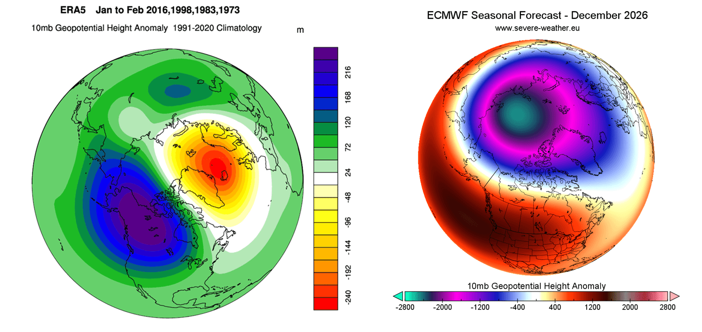
Meteorological institutions, including the ECMWF and NOAA, are utilizing high-resolution ensemble forecasting to track these developments. Recent seasonal forecasts show the zonal wind strength at the 10mb level (30km altitude) dropping significantly below the long-term average by January 2027.
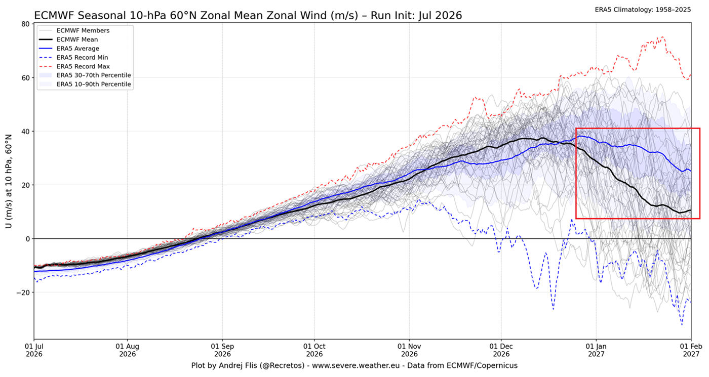
When the stratospheric winds slow down, it is the primary indicator of a Sudden Stratospheric Warming (SSW) event. An SSW event causes the temperature in the stratosphere to spike, sometimes by tens of degrees in a matter of days. This thermal surge causes the vortex to stretch, split, or completely dissipate. The 3D structural analysis of the atmosphere suggests that we are entering a period where the "polar wall" is increasingly susceptible to this kind of thermal intrusion.
Official Perspectives and Scientific Consensus
Meteorologists emphasize that a "disruption" is not a guarantee of a uniform deep freeze for every town in the Northern Hemisphere. Rather, it creates a "blocking pattern."
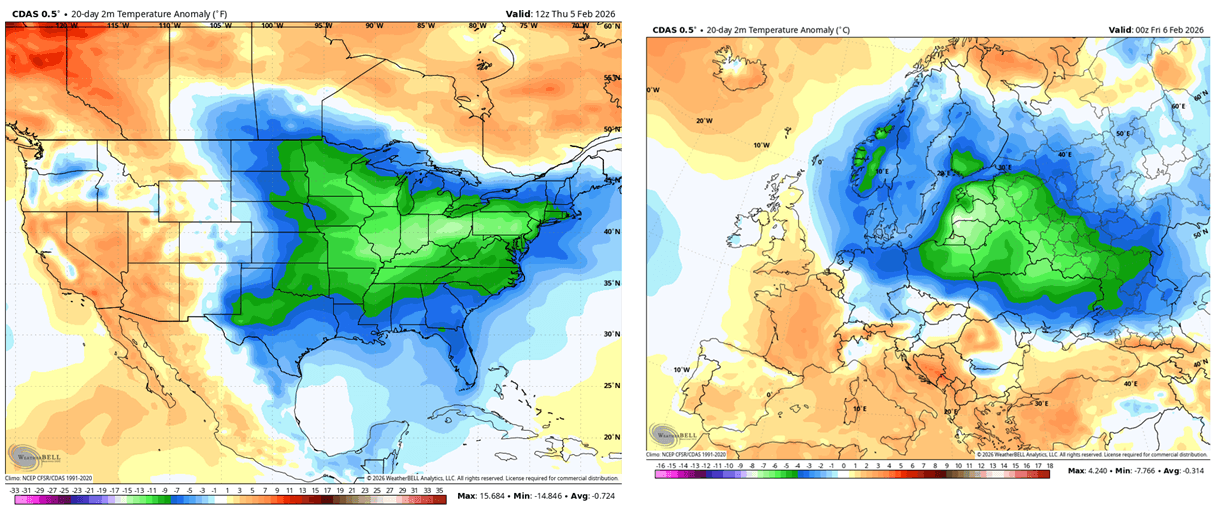
"A disrupted vortex changes the ‘pathway’ of the jet stream," says Dr. Zachary Labe, an expert in Arctic climate research. "When the jet stream becomes wavy, you end up with extreme temperature gradients. One region might experience a record-breaking heat anomaly, while a neighboring region faces an ‘Arctic Express’ of sub-zero temperatures."
The scientific consensus is that the combination of these three factors (El Niño, QBO, and sea ice) creates a high-probability environment for a "split-vortex" event. In such a scenario, the vortex core moves from the pole, often settling over North America or Northern Europe, creating a high-impact weather regime that can last for several weeks.
Implications: What This Means for Winter 2026/2027
For the general public, infrastructure managers, and energy grid operators, the implications are significant.
Increased Energy Demand
If the Polar Vortex undergoes a major disruption, the resulting cold outbreaks will likely spike demand for heating fuel and electricity. Previous years that featured similar stratospheric warming events saw a direct correlation with increased volatility in energy markets.
Transportation and Logistics
The potential for a "blocking pattern" implies that winter storms may become more stationary. Instead of fast-moving systems, we could see "stuck" weather patterns, leading to heavy, persistent snowfall in the Midwest, Eastern United States, and parts of Europe. This presents a high risk for travel disruptions, aviation delays, and infrastructure strain.
Agricultural and Economic Impact
For the agricultural sector, the timing is critical. While a cold winter is often standard, a disrupted vortex can bring cold snaps after a period of relative warmth, leading to potential damage to winter crops. Furthermore, the volatility in extreme weather events—ranging from heavy snow to flooding—creates a complex landscape for insurance and economic planning.
Moving Forward: Monitoring the "Pulse"
As we move toward the winter months, the focus of the global meteorological community will shift to real-time stratospheric monitoring. The "warning signs" we are seeing today—the warm Pacific, the shifting equatorial winds, and the melting Arctic ice—are the precursors to a potentially historic winter.
We urge readers to stay informed. The situation remains fluid, and the exact trajectory of the Polar Vortex will depend on the intensity of the stratospheric wave energy throughout November and December. By bookmarking our updates, you can track the progress of these climate signals as they evolve.
The winter of 2026/2027 is shaping up to be a masterclass in global atmospheric connectivity. Whether the vortex holds firm or yields to the pressure of the Pacific, the impact on our daily lives will be undeniable. We will continue to provide deep-dive analysis as the data becomes available, ensuring you have the most accurate, science-backed outlook for the months ahead.
For further reading on the intersection of oceanic anomalies and atmospheric circulation, please refer to our deep-dive analysis on the 2026/2027 Seasonal Weather Shift.